
Yardang (Hill)..................................................................................................................................................................................................................................Iardang
Iardangue / Yardang / Yardang / 雅丹地貌 / Ярданг / Yardang (collina) /
Rock ridge carved by wind in desert environments. Yardangs are elongate structures, typically, three or more times longer than wide, which when viewed from above, resemble the hull of a boat.
See: « Desert »
&
« Erosion »
&
« Dune »
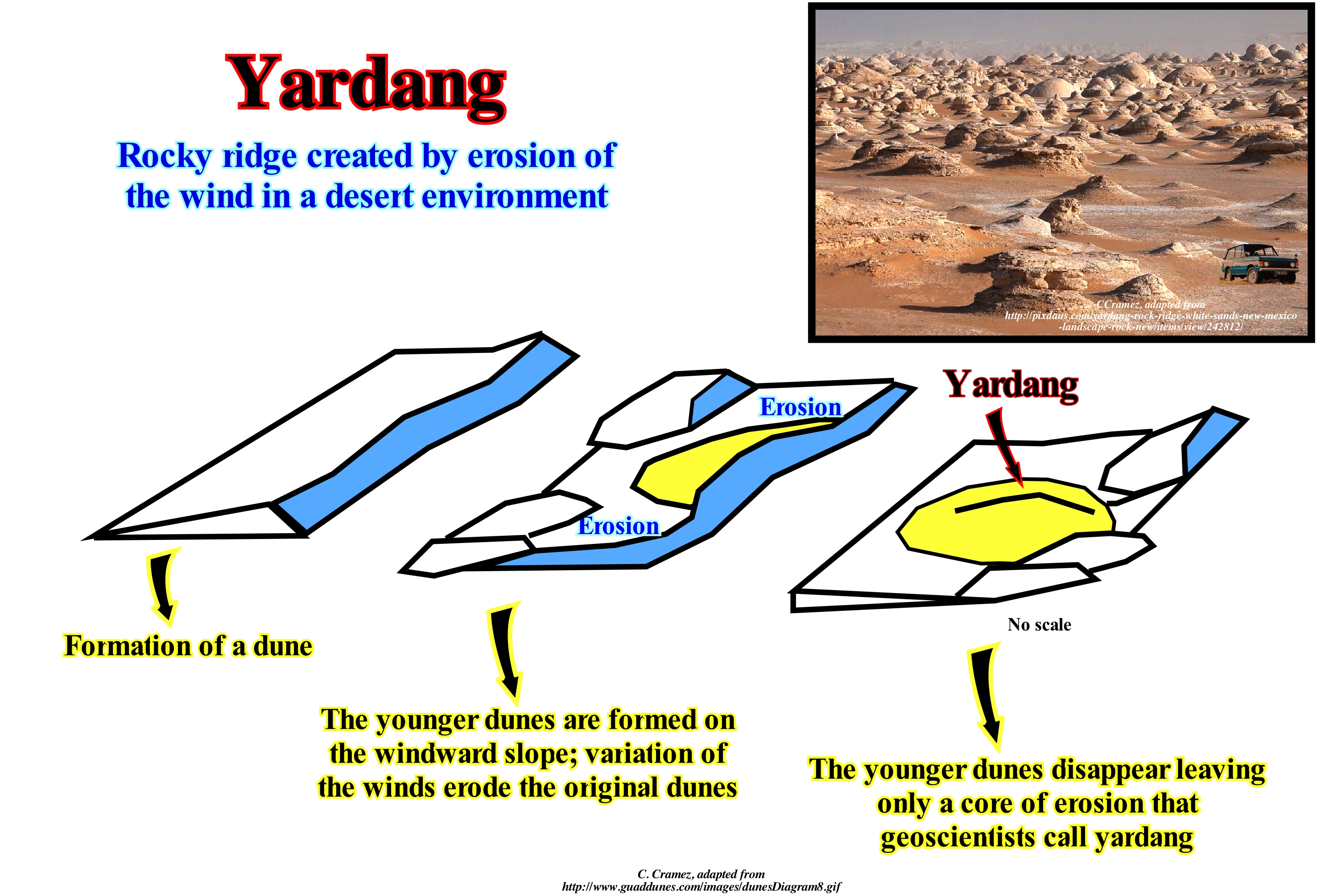
Yardangs are ridges with about 15 meters formed by the erosion of layers of rock, alternately, resistant and tender. The yardangs can be found in most deserts. Depending on the winds and the composition of the deposits, the yardangs may have very strange shapes (some resemble various objects and even people). In yardangs, the windward side (exposed to the wind) is abrupt and the structure becomes lower and narrower as we move away from the wind. As stated above, unlike most mounts carved by water and mass loss, the yardangs are, typically, three or more times longer than wide. Individually, yardangs range from a few centimeters to several kilometers in length and from a few centimeters up to 30 m or more in height. Along the base of each flank of the yardangs, especially in the great yardangs, significant grooves are very common. These grooves, cut by abrasion, mark the location of the denser part of the sediment load carried by the air. Yardangs are, usually, taller and broader on the flank facing the wind, and smaller and narrower at the leeward (flank oriented in the direction of the wind). Yardangues may be isolated, or they may occur in groups, called fields (or fleets, since they resemble the hooves of inverted vessels). The small yardangs about 2/4 m high are, usually, carved in semi-solid sediments of the "playas*" or other relatively soft sediments or granular materials. In arid regions with strong winds blowing almost always in the same direction, yardangs with several kilometers long can be carved in siltstones, sandstones, shales and limestone but, rarely, on crystalline rocks such as gneiss. Most of these large yardangs form part of a large area of grooved land, although fleets or fields of yardangs with no associated ridges are also found in more or less isolated outcrops.
(*) Playas also called pans, flats, or dry lakes, flat-bottom depressions found in interior desert and adjacent to coasts within arid and semiarid regions, periodically covered by water that slowly filtrates into the ground water system or evaporates into the atmosphere, causing the deposition of salt, sand, and mud along the bottom and around the edges of the depression.(https://www.britannica.com/science/playa)
Yazoo-Type River...........................................................................................................................................................................Fleuve type-Yazoo
Rio tipo Yazoo / Río tipo-Yazoo / Yazoo-Typ Fluss / 亚祖 - 型河流 / Приток, текущий параллельно основной реке / Fiume tipo-Yazoo /
Tributary river unable to enter the main stream due to the natural levees. The term comes from the Yazoo river that runs parallel to the Mississippi river for about 280 km before converging, being constrained from doing so upstream by the river's natural marginal dikes (levees) and man-made marginal dikes.
See : « Levee (natural) »
&
« Bayline »
&
« Meander »
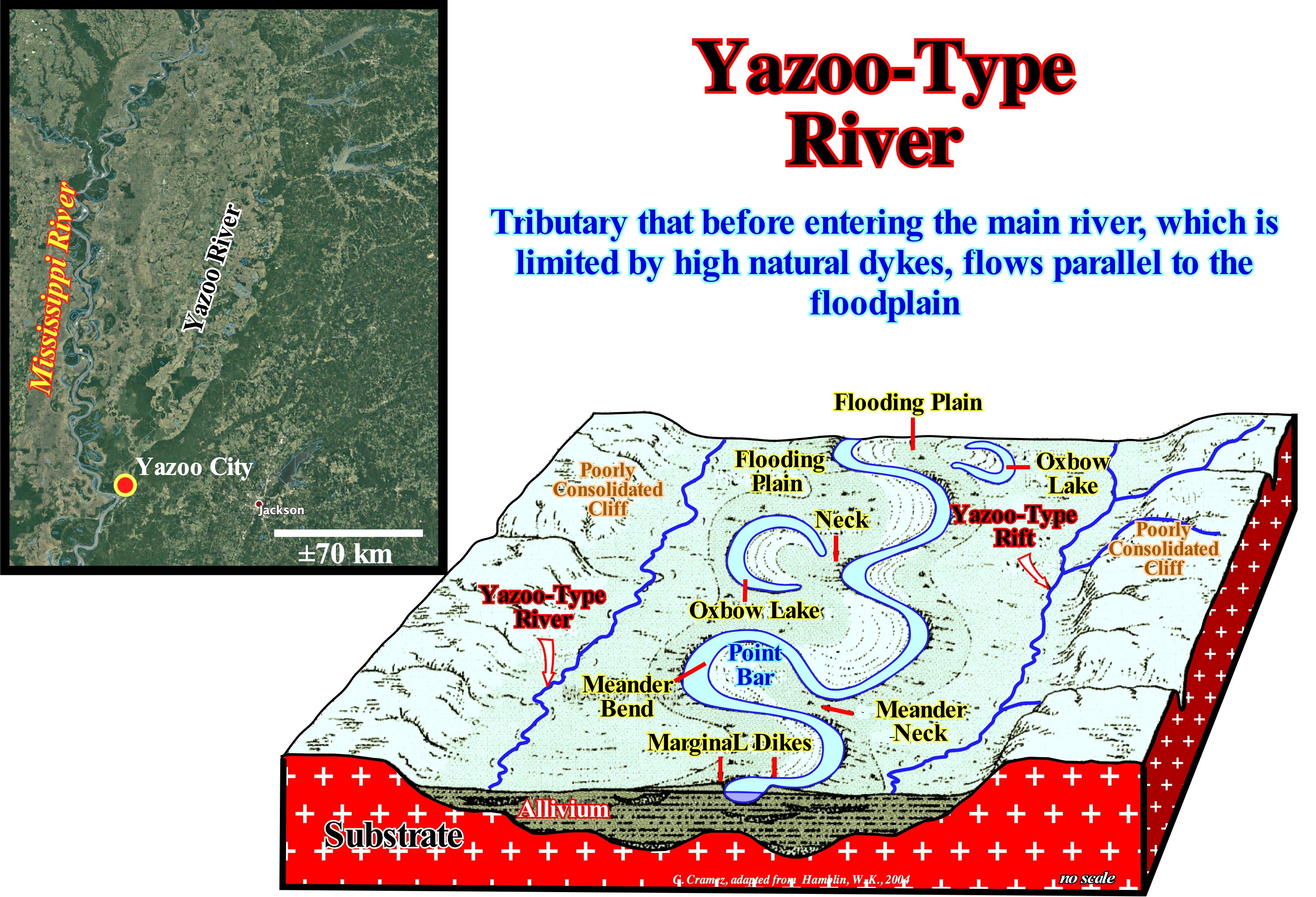
As illustrated in this scheme, a Yazoo-type river runs in the outer (back) zone of the marginal marshes, parallel to the main river, until, eventually, find, downstream, a main river entrance. Usually, this occurs when the river is near the maturation stage and natural dikes develop on the margins and relatively higher than the surrounding floodplain. Under these conditions, tributary rivers are unable to drain into the main channel and form lakes or flow parallel to the main river. The term Yazoo-type river comes from the Yazoo river that runs parallel to the Mississippi River for about 280 km before converging. So it became a geologic and hydrologic term for any tributary* stream, which is forced to run parallel to the base of then main natural marginal dikes (fluvial levees) within the floodplain of a larger river for a significant distance before, eventually, joining it .The typical example of the Yazoo River is the Memphis River (Tennessee, USA), northward of Yazoo River, which flows parallel to the Mississippi River for more than 400 km. This river flows into Mississippi, in the Vicksburg region, because the banks of the Mississippi River are very high and prevent its tributary from entering the main channel, causing it to seep through the floodplain (variable width between 35 and 150 km), parallel to the main channel and with a gradient of about 11.4 cm per kilometre. Yazoo-type channels have been described in underwater drainage systems in association with deep mid-ocean channels. However, Yazoo-type tributaries and associated deposition systems typically contrast with deep turbidite systems. The submarine fans, whether they are from the basin or slope, are systems of dispersion of the sediments transported along the submarine valleys and canyons. The Yazoo-type submarine channels, on the contrary, form convergent and centripetal systems of the distributary, which join together in the drainage basin of the main mid-oceanic channel. The architecture of such systems is characterized by a disordered aggradation of fining grained intervals with sandy channel fills and submarine point bars embedded in the underwater overbanking deposits. Second-order channels contain sandy overbank deposits, where the natural marginal dykes of the main channel are mainly composed of shales and silts. These 2nd order channels can be intertwined and form wide deep plains.
(*) A tributary or affluent is a stream or that flows into a larger stream or main stem (or parent) river or a lake. A tributary does not flow directly into a sea or ocean. Tributaries and the main stem river drain the surrounding drainage basin of its surface water and groundwater, leading the water out into an ocean. (https://en.wikipedia.org/wiki/Tributary)
Ypres...............................................................................................................................................................................................................................................................................................Yprés
Ypres / Ypres / Ypern / 伊珀尔 / Ипр / Ypres /
The oldest geological age (time) or the lowest stratigraphic stage (rocks) of Eocene.
See : « Geological Time »
&
« Stratigraphy »
&
« Geological Time Scale »
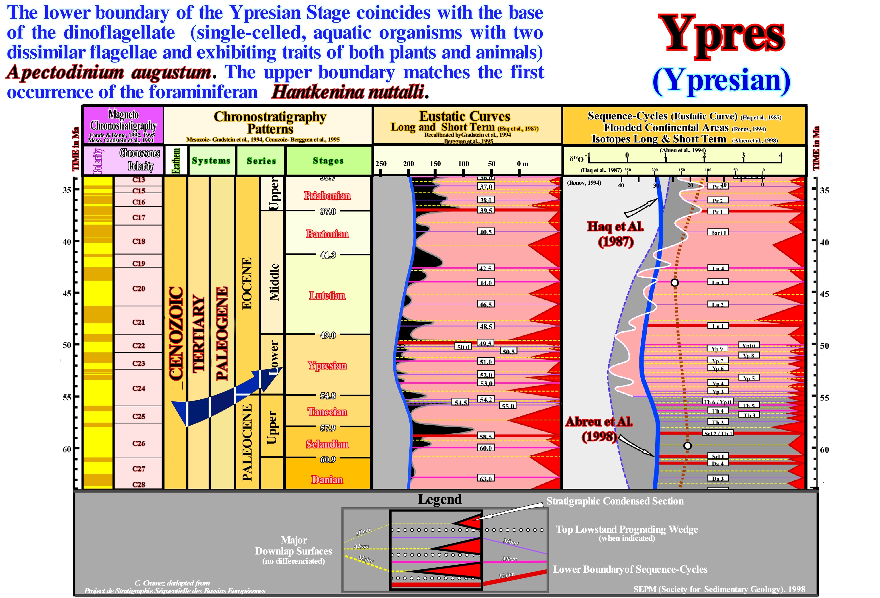
Chronostratigraphic units (rocks), such as systems, are the basis of the Phanerozoic time scale. These units have a hierarchy*: (i) Eonothem, set of strata that were deposited during an Eon, such as during the Phanerozoic ; (ii) Erathem, set of strata deposited during an Era such as during the Paleozoic ; (iii) System, set of rocks deposited during a Period such as during Devonian ; (iv) Serie, set of strata deposited during a Epoch, such as during Late Devonian ; (v) Stage, set of strata deposited during an Age as, for example, during Frasnian ; (vi) Substage, which is the set of strata deposited in a Subage ; (vii) Chronozone, set of layers deposited during a chron. On the geological time scale*, the Ypresian is an age of the Eocene epoch of the Paleogene period of the Cenozoic era of the Phanerozoic eon, approximately between 54.8 million and 49 million years ago. The Ypresian age (Eocene series) comes after the Tanethian age of the Paleocene series and precedes the Lutetian an age of its series (Middle Eocene). The Ypresian is, often, included with Lutetian in the initial Eocene series. The Ypresian age was introduced in the scientific literature by the Belgian geoscientist André Dumont in 1850. In his communication to the Royal Academy on November 10, 1849, André Dumont said: "The Eocene lands are divided into three systems which I have called Landenian, Ypresian, and Bruxelian. The Ypresian system, which I separate from the Landenian because it seems to me more marine than fresh water, and because it has a great development in the hills of Ypres in West Flanders, shows, at its lower part, a thick clayey mass and in its upper part, fine sands with glauconite which, in some areas, contains a bank of numulites ". The name Ypresian derives from Ypres, which is the French name of the Belgian city of Ieper (Flanders). The original settings of this stage are, totally, different from the modern definitions. The Ypresian base is defined by a strong anomaly in the δ13C values (ratio of two stable carbon isotope the, 13C/12C, expressed in "per thousand, i.e., ‰) of the MTPE ("Paleocene-Eocene Thermal Maximum"). The official reference profile (GSSP, acronym of Global Boundary Stratotype Section and Point, which is the internationally agreed upon reference point on a stratigraphic section which defines the lower boundary of a stage on the geologic time scale) for the Ypresian base is the Dababiya profile near of the Egyptian city of Luxor, although the original section-type is located near the city of Ypres. In this area, the thickness of the Ypresian deposits increases northward. A few meters in the south and southeast, about 150 m in the northern part of the basin, with a maximum thickness observed in the north-west end (± 182 meters). The top of the Ypresian (Lutetian base) is identified by the first appearance of the foraminifera Hantkenina genus in the fossils. The famous fossil bituminous shales of Messel*** (Germany) are of Ypresian age.
(*) The conventional hierarchy of the equivalent geochronologic units (time) are: (i) Eon ; (ii) Era ; (iii) Period ; (iv) Epoch ; (v) Age ; (vi) Subage, etc.
(**) System of chronological dating relating geological strata (stratigraphy) to time. It is used by geoscientists (geologists, paleontologists, and other Earth scientists) to describe the timing and relationships of events that have occurred during Earth's history.
(***)The Messel Grube (pit) is a disused quarry near the village of Messel, about 35 km southeast of Frankfurt (Germany), where Ypresian fossiliferous bituminous shales were mined since 1859 til 1971. The shales seem to be deposited in a series of lakes, surrounded sub-tropical forests supported an incredible diversity of life, which were, probably, a central drainage point from nearby rivers and creeks.
Ypresian..............................................................................................................................................................................................................................................Yprésien
Ypresiano (Ipresiano) / Ypresiano (Ipresiano) / Ypresium / 伊普雷斯阶 / Ипрский ярус (палеогеновой системы) / Ypresiano /
The oldest and the lowest stage of Eocene series of the Paleogene system. The Ypresian lasted between 54,8 and 49,0 Ma, i.e., after he Tanethian and before the Lutetian.
See : « Geological Time »
&
« Geological Time Scale »
&
« Formation (geological) »
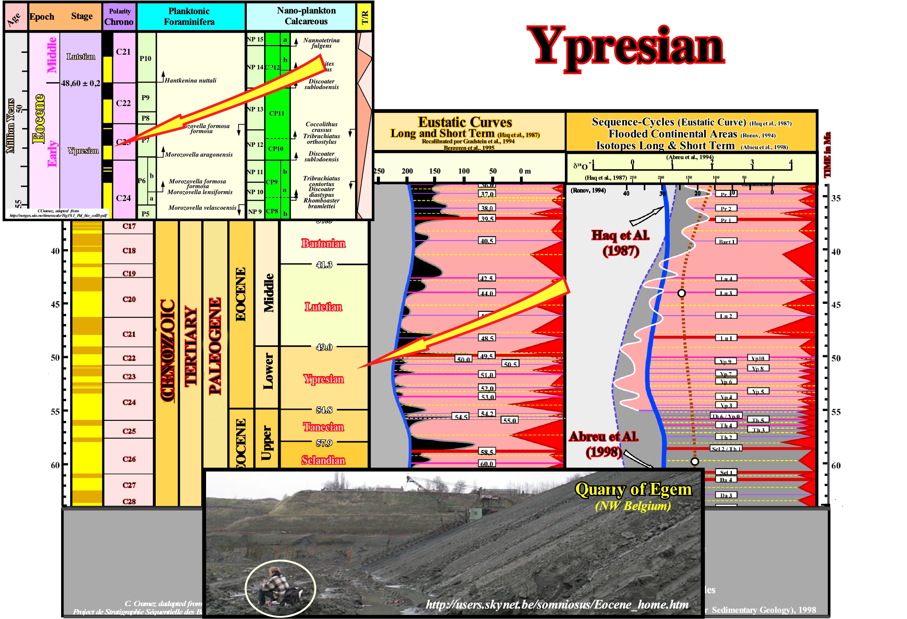
The Ypresian is an Eocene subperiod. It lasted from 54.8 Ma to 49 Ma and was the first subperiods of the Eocene period. It is characterized by high temperatures that have allowed forests to spread worldwide from Antarctica to Arctic and Greenland. Its subtropical environment has favoured the development of different types of plants, as well as the expansion of mammals favouring their diversity, for example, the first cetaceans appear in the aquatic environment, while on land the ancient mammalian lineages of today appeared as the horses and ancestors of carnivores. (http://es.prehistorico.wikia.com/wiki/Ypresiano) On the geological time scale, the Ypresian is the age of the Paleogene era of the Paleozoic era of the Phanerozoic eon. The Ypresian stage (Eocene series) comes after the Tanethian age of the Paleocene series and precedes the Lutetian age of its series (Middle Eocene). The Ypresian is often included with Lutetian in the early Eocene series. The Ypresian stage was introduced into the scientific literature by Belgian geoscientist André Dumont in 1850. In his communication to the Royal Academy on November 10, 1849, André Dumont said: "The Eocene lands are divided into three systems that I called Landenian, Ypresian and The Ypresian system, which I separate from the Landenian because it seems to me more marine than fresh-water, and because it has a great development in the Ypres hills of West Flanders, shows at its bottom a thick, clayey mass. at its top, fine sands with glauconite which in some areas contain a bank of numulites* ". The name Ypresian derives from Ypres, which is the French name of the Belgian city of Ieper (located in the NO of Belgium in the Westhoek region of West Flanders province). The original definitions of this floor are totally different from the modern definitions. The basis of the Ypresian is defined by a strong anomaly in the δ13C values of the MTPE ("Paleocene-Eocene Thermal Maximum"). The official reference profile (GSSP, international agreement on the stratigraphic sections that serve as reference for the geological time scale, i.e. "Global Boundary Stratotype Solutions and Point"), for the base of the Ypresian is the Dababiya profile near from the Egyptian city of Luxor, although the original type section is located near the town of Ypres. In this region, the thickness of the Ypresian deposits increases to the north from a few meters in the far south and southeast to about 150 m in the northern part of the basin, with a maximum thickness observed in the far Northwest (± 182 m). The top of the Ypresian (Lutetian base) is identified by the first appearance of the foraminifera genus Hantkenina in the fossils (Hantkenina is a genus of planktonic foraminifera of the Family Hantkeninidae, Superfamily Hantkenioidea, Suborder Globigerinas and Order Globigerinas, whose type is Hanktenina alabamensis and whose chronostratigraphic range is from Lutetian to the Bartonian). The photo (Quarry of Egem, in NW Belgium) illustrates the Early Eocene (Ypresian) and Middle Eocene (Lutetian) in Belgium. The quarry sediments presents a very rich and diverse elasmobranch fauna** of mid-late Ypresian age. This part of the Ypresian is absent in the Paris geographic basin and very weakly present in Hampshire geographic basin (UK). The sedimentation seems to took place in shallow water environments under a subtropical climate. More than five layers contain vertebrate remains are exposed. The fauna assemblages are very different. The famous Fossil Bituminous Shales from Messel (Germany) are, also, of Ypresian age. The Ypresian/Lutetian stratotype boundary is based on an event that can correlate with the Lutetian (standard Eocene stage) base. The Lutetian was defined by De Lapparent in 1883 and revised in 1983 by Bundle, who proposed a new stratotype about 50 km north of Paris. The concept of the Ypresian stage or Ypresian synthem, as some geoscientists say, was introduced by A. Dumont in 1849 to specify marine clays and the overlying glauconitic sand occurring in the Ieper region of western Belgium.
(*) The numulites are a species of foraminifera (Protozoa), mainly known as fossils and which have the following characteristics: hard shell, limestone, pierced by thin multilocular channels. Spins arranged in a spiral or circle. Partitions composed of two compact limestone lamellae that line the interior of the walls. Between the wall lamellae there is often a branched channel system; The walls are pierced only a small number of pores. (http://www.cosmovisions.com/nummulites.htm)
(**) Elasmobranchii is a subclass of Chondrichtyves (cartilaginous fish), including the sharks (superorder Selachii) and the rays, skates and sawfish (superorder Batoidea). Members of this subclass are characterised by having five to seven pairs of gill clefts (extracts dissolved oxygen from the water and excretes carbon dioxide) opening individually to the exterior, rigid dorsal fins and small placoid scales on the skin.


Send E-mails to carloscramez@gmail.com or to carlos.cramez@bluewin.ch with comments and suggestions to improve this glossary.
Copyright © 2009 CCramez, Switzerland
Last updated: September, 2019